Here’s our list of the top beauty spots in Angus chosen by the people who live here and those who can’t get enough of this wild and wonderful corner of Scotland.
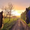
From serene lochs and majestic waterfalls to rolling hills and enchanting forests, Angus offers endless natural beauty to discover.

Arbirlot, a picturesque little village near Arbroath, is home to a spectacular 23-foot waterfall. You reach the waterfall using the Arbirlot Natural Trail – a family-friendly, four-mile walk through stunning Angus countryside following a small river, the Elliot Water. The walk starts in a small public car park at Elliot, just off the A92 as it enters the outskirts of Arbroath from the south.
Your walk will follow the trackbed of an old Angus railway line. It provides a well-graded path for a pleasant stroll from Elliot to Arbirlot. The village dates back at least to 1000AD when it is believed that Danish Invaders destroyed the first church here.
The attractive waterfall and rustic stone bridge, together with the dramatic countryside that surrounds it, makes this spot well worth a visit at any time of the year. But it’s an exceptionally beautiful spot to admire in its autumn colours.

Carrot Hill is a small, 850-feet summit in the Sidlaw Hills. It provides spectacular views across Strathmore, from the low-lying fertile fields on the floor of the Strath, stretching east and west as far as the eye can see, to the Cairngorms in the north. This view is considered one of the best in Angus, so it’s worth stopping for a while to admire it.
Follow the B978 from Dundee through Kellas to the hamlet of Bucklershead and take the road to the left signposted West Denhead. Follow this narrow road through the rolling Angus countryside as it climbs gently taking you through a forest of conifers. As you emerge from the trees, you’ll see the conveniently-located car park and get your first glimpse of the dramatic view.
The unforgettable scenery makes this the perfect place for a walk in all seasons and weather. This is a perfect place if you’re looking for somewhere special to walk your dog.

The Brown and White Caterthuns are a pair of large hill forts on adjacent hills overlooking Strathmore and enclosed by a series of earthworks. Visit the Caterthuns to enjoy spectacular views from two of the most impressive Iron Age hilltop enclosures in Scotland.
It’s likely the Caterthuns had multiple functions in the past, serving both as military and ceremonial centres. Their names relate to the method of construction; the Brown Caterthun is defended by four earth ramparts, now heather covered. The White has a large stone rampart and ditches. They may have even been one site with two summits.
The Caterthuns can be found west of Edzell, around five miles east of Inchbare village, off the B966 Brechin to Edzell Road. You can visit both by short, easy walks from a layby on the road that runs between the two.
Your visit here will be a memorable experience, thanks to the extraordinary views towards the glens and across Strathmore.

Part of the Cairngorms National Park, Glen Clova is an excellent hillwalking destination. Loch Brandy is a beautiful part of this glen, located nearly 610m (2,000 feet) above sea level on the western slopes of the Green Hill above Glen Clova.
Loch Brandy is a superb example of a mountain corrie, backed by craggy slopes and cradling the perfect loch. The entire area around Loch Brandy creates an incredible landscape that needs to be seen to be appreciated. Before you lies a deep pool of dark water snuggling in the curving arms of rock which rise up dramatically from the quiet shores.
The walk to the loch is an accessible but challenging route among beautiful scenery. Although it is a short walk, you must wear appropriate clothes and footwear and be prepared for changes in weather. However, once you reach your destination, the views are spectacular and worth every bit of effort. The Glen Clova Hotel and some well-earned refreshments are waiting for you on your return.

Elephant Rock is a naturally-formed coastal arch of volcanic rock nestled in a secluded bay that has been shaped by the elements. The rock closely resembles the shape of an elephant’s head and truck. The walk to Elephant Rock and the adjacent coastal path offer breathtaking views across the North Sea.
The route to Elephant Rock is a coastal walk with a difference. It features the grave of a man who apparently died 19 years before he was even born. When George James Ramsay was buried in the tiny cliff-top cemetery just north of Boddin Point, an error was made on the headstone. Beneath ‘In Memory of George James Ramsay’ the inscription on the sea-facing stone reads: ‘Born November 24, 1859, Died December 17, 1840’.
How this happened and why the memorial was never altered is a mystery. But it forms a fascinating part of a pleasant and accessible walk along the beautiful coastline from Boddin to Ferryden.

Hidden away at the end of Glen Clova lies Glen Doll, a spectacular glen carved by glaciers. And within Glen Doll, you’ll find Corrie Fee – a truly dramatic location and a National Nature Reserve. It is considered one of the most picturesque spots in Scotland; a massive bowl scooped out from the rugged mountainside by a glacier during the Ice Age.
Corrie Fee is an exceptional place to see all sorts of rare alpine plants. It has been designated for its rare alpine floral community; some of the plants that grow here cannot be found anywhere else in the UK. A memorial garden in Forfar pays tribute to the famous local botanist George Don and other local significant botanists who often spent time at Corrie Fee.
The corrie is only a few miles along beautiful forest tracks from Glen Doll. For a more challenging return journey, you can climb out of the corrie up the side of Fee Burn.

Pronounced locally as ‘Mon-trim-ont’, the woodland is an extensive, mainly coniferous woodland three miles south of Brechin. It’s a beautiful location for walks in the Angus countryside. The forest is home to a host of wildlife, including buzzards, owls, woodcock, cuckoos, red squirrels, pine marten and deer.
The site is around 1,700 acres with numerous access points and ample parking. The network of tracks is popular with walkers, mountain bikers and even husky racers in the winter.
Montreathmont has a unique but now hidden history. It was the location of the Montreathmont Camp Radio Station in World War II and used as Airship Station in WW1. The listening and radio station began as a secret listening post and codebreaking centre which operated as an outstation of Bletchley Park during World War II. It continued to monitor communications during the Cold War. You can see remains of the site and mooring pits for the airships in the woodland.

In the Scots language, a ‘Strath’ is a wide river valley of flat, fertile land bounded by hills, and this precisely defines the Vale of Strathmore. Strathmore (known as ‘The Great Glen’) forms a wide valley between the southern Grampians and the Sidlaw Hills, extending from Perth in the southwest to Stonehaven in the northeast. It is approximately 50 miles (80 km) long and 10 miles (16 km) wide.
Lumley Den sits within the valley, a former glacial overflow channel located south of Glamis near Glen Ogilvy. You can enjoy an interesting and scenic walk here, coming across an isolated cottage, disused quarries and a small, narrow loch on your travels.
Angus Hill offers beautiful panoramic views across Strathmore up to the Angus Glens. The view north across the Vale of Strathmore is always postcard-perfect regardless of the weather. The hill is just a few minutes drive from the A90 and will soon have a new interpretation board that will highlight the hills you can see from the site and explain the landscape before you.

Welcome to an amazing hidden gem. The Shakin Brig (shaking bridge) is a suspension bridge that crosses the River North Esk in the idyllic village of Edzell.
Reach the Shakin Brig from Edzell’s High Street, strolling down a narrow lane called Gassie Brae. Step foot on the bridge, and you’ll experience the shaking sensation that gives the bridge its name. It was constructed around 1900 but is well-maintained and completely safe (and fun!) for all the family.
Stop on the bridge a while to appreciate the natural beauty of your surroundings. Enjoy the peaceful sound of the river as it flows lazily beneath your feet and gathers in cool pools. And look out for splashing salmon.
Reach the other side to find some sheltered pebble beaches. Try your hand at skimming stones or even dip your feet in the water. From here you can take pleasant woodland walks following the river’s path.
Please note – due to storm damage, the Shakin Brig is currently not accessible to pedestrians.

Kinpurney Hill, near Forfar, forms part of the Sidlaw Hills. Kinpurney Tower sits around 345m above sea level at the top and is one of the most prominent landmarks in Angus, visible for miles around. The tower was built in 1774 by James MacKenzie, a keen astronomer, and used as an observatory. It was restored in the 1970s and stands next to the site of an unfinished iron-age fort.
The enjoyable walk to the top of Kinpurney Hill starts at Tealing and follows an old mill stream before moving out to open hillside. Kinpurney Tower is visible for most of the walk, except on the south side where there is a steep natural slope, and in the west where there is a break for the single entrance.
Once at the top, you’ll enjoy beautiful views in all directions. You will be able to see right across Strathmore to the Angus Glens.
You can take public transport to Newtyle or park on Glamis Road on the east edge of Newtyle. View Walk Highlands for a more detailed route map.